|
|


We know Surveying

With our decades of experience,
professional level prersonel, and the
latest in equipment technology, we
are able to continually perform
on-spec and on-time for our clients.
Our unique experience in airport surveying, heavy highway, bridge layout, and wide area projects has made the surveying teams at Wilkinson & Associates some of the most experienced in the field.
Our unique experience in airport surveying, heavy highway, bridge layout, and wide area projects has made the surveying teams at Wilkinson & Associates some of the most experienced in the field.


Land Surveying
Boundary and Topographic surveying
We provide our clients with detailed boundary, location, and topographic surveys sufficient for their design and land development needs. With well over a decade of experience in the land surveying field, we have the experienced staff and latest in equipment to perform our field work in a timely fashion. In the office, our experienced professionals specialize at compiling the field data into detailed, accurate drawings. For large scale projects we coordinate the use of aerial mapping, combined with ground based surveying to supplement areas where elevation data is critical. In addition, we supplement surveys with utility one-call information where required.
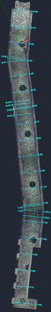
Laser Scanning/Point Cloud Creation
We provide our clients in various Architectural and Engineering disciplines with high quality drawings generated from scanned point clouds. We utilize high speed laser scanning and specialized software to effectively generate drawings from scanned information. From top view floor plan drawings, to as built surveys of mechanical piping, we are able to provide cost effective solutions.
ALTA/ACSM Land Title surveys
In addition to our traditional base mapping, we also provide our clients with ALTA/ACSM Land Title surveys when required, adhering to the latest specifications, complete with a detailed review of the Schedule B Section II documents provided with the title report.
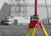
Global Positioning Surveys
We provide various levels of GPS surveying, from GIS type locating, to real time kinematic (RTK) surveying across a large site. In addition to our own base stations, we are also a participant in the latest Trimble VRS grid system which permits us centimeter accurate, real time surveying throughout the Northeastern U.S. and Texas.
3D Modeling and Grade Control
We create 3D models from design drawings and files, and export a variety offormats, such as Topcon and Trimble machine control systems, for machine control in the field. We produce survey grade models, with the level of detail required for accurate, buildable models ready for the field.
As Built Surveying
When the construction of a commercial or residential project nears completion, we understand the importance of our clients needing the final as built survey performed. We typically expedite this type of project, as we understand the As Built survey is often the final step required prior to a construction projects completion and release of bonds. We are diligent in recognizing and adhering to the particular as built requirements for the city, township or municipality where the project reside.
Commercial Layout
For our commercial clients, we offer field layout and surveying services for a variety of needs. From building and column layout to anchor bolt verification, control lines, or checking plumb alignment, we provide timely and efficient service. We have the experience to efficiently setup layout from construction plans, with the ability to recognize inconsistencies in dimensions and layout prior to setting in the field. With our years of experience, from below ground to above ground, we have the in-depth
understanding of commercial layout to be an asset on your next project.
Heavy Highway
Our staff has many years of experience in the construction layout of roadways, bridges, tunnel and culvert systems, airport runways and appurtenances, and the unique issues involved in these types of projects. We are experienced in the establishment of high precision control and coordination for projects of this magnitude, and utilize the latest in instrument robotics to achieve the accuracy and efficiency demanded in this industry.
We provide our clients with detailed boundary, location, and topographic surveys sufficient for their design and land development needs. With well over a decade of experience in the land surveying field, we have the experienced staff and latest in equipment to perform our field work in a timely fashion. In the office, our experienced professionals specialize at compiling the field data into detailed, accurate drawings. For large scale projects we coordinate the use of aerial mapping, combined with ground based surveying to supplement areas where elevation data is critical. In addition, we supplement surveys with utility one-call information where required.
Laser Scanning/Point Cloud Creation
We provide our clients in various Architectural and Engineering disciplines with high quality drawings generated from scanned point clouds. We utilize high speed laser scanning and specialized software to effectively generate drawings from scanned information. From top view floor plan drawings, to as built surveys of mechanical piping, we are able to provide cost effective solutions.
ALTA/ACSM Land Title surveys
In addition to our traditional base mapping, we also provide our clients with ALTA/ACSM Land Title surveys when required, adhering to the latest specifications, complete with a detailed review of the Schedule B Section II documents provided with the title report.
Global Positioning Surveys
We provide various levels of GPS surveying, from GIS type locating, to real time kinematic (RTK) surveying across a large site. In addition to our own base stations, we are also a participant in the latest Trimble VRS grid system which permits us centimeter accurate, real time surveying throughout the Northeastern U.S. and Texas.
3D Modeling and Grade Control
We create 3D models from design drawings and files, and export a variety offormats, such as Topcon and Trimble machine control systems, for machine control in the field. We produce survey grade models, with the level of detail required for accurate, buildable models ready for the field.
As Built Surveying
When the construction of a commercial or residential project nears completion, we understand the importance of our clients needing the final as built survey performed. We typically expedite this type of project, as we understand the As Built survey is often the final step required prior to a construction projects completion and release of bonds. We are diligent in recognizing and adhering to the particular as built requirements for the city, township or municipality where the project reside.
Commercial Layout
For our commercial clients, we offer field layout and surveying services for a variety of needs. From building and column layout to anchor bolt verification, control lines, or checking plumb alignment, we provide timely and efficient service. We have the experience to efficiently setup layout from construction plans, with the ability to recognize inconsistencies in dimensions and layout prior to setting in the field. With our years of experience, from below ground to above ground, we have the in-depth
understanding of commercial layout to be an asset on your next project.
Heavy Highway
Our staff has many years of experience in the construction layout of roadways, bridges, tunnel and culvert systems, airport runways and appurtenances, and the unique issues involved in these types of projects. We are experienced in the establishment of high precision control and coordination for projects of this magnitude, and utilize the latest in instrument robotics to achieve the accuracy and efficiency demanded in this industry.
w w w . w i l k i n s o n a s s o c . c o m
The Land Surveying services we provide at
Wilkinson & Associates, Inc. serve as the
foundation for our engineering services
offered to our Land Development,
Architectural, and Oil & Gas clients. We
provide land surveying services to clients
throughout the Northeast and Southwest
states. From initial topographic and location
surveys for base mapping, to highly detailed
point cloud scanning, we have the
technology and experience to meet all your
survey needs.